
The Coastal Trail Insignia:
The design of the CCT emblem took place over a six month period in 2005. The Coastal Conservancy, in conjunction with Coastwalk, worked with design consultants to identify a variety of factors and elements that would be critical to a successful emblem design. Beginning with over 100 alternatives, the design options were narrowed down with input from public agencies and the public. All of this input was integrated into the final design endorsed by the Coastal Conservancy Board in December of 2005.
In its basic form, the iconic wave in a circle of blue is imprinted on squares of aluminum that are set on posts or incorporated into informative trail signs posted along the California Coastal Trail to help identify the alignment of the CCT to visitors.
Read more about the CCT insignia design and selection process.
Marking the California Coastal Trail
Coastwalk, in partnership with the California Coastal Conservancy and California State Parks launched a major effort in 2005 to mark the California Coastal Trail with it’s the CCT insignia. Trail markers provide, in many cases, an individual’s first inkling that a beloved local trail is part of the larger network of trails comprising the California Coastal Trail.
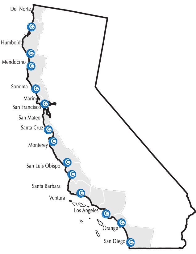
This initial trail making project resulted in over 118 miles of CCT signed with 374 markers placed at locations in indicated by the Trail insignia on the map.
Humboldt County:
- Patrick’s Point (13 markers – 1.5 miles)
- Lost Coast – King’s Range (3 markers – 30 miles)
Mendocino County:
- Lost Coast – Sinkyone Wilderness (3 markers – 22 miles)
- MacKerricher State Beach (6 markers – 8 miles)
- Russian Gulch (4 markers – 1 mile)
- Navarro Point ( 3 markers – 1.5 miles)
- Gualala Bluff (7 markers – 25 miles)
Sonoma County
- Fort Ross Reef Trail (5 markers – 0.75 miles )
- Kortum Trail (18 markers – 3.5 miles)
- Doran Beach (3 markers – 0.3 miles)
San Francisco County
- GGNRA (200 markers – 16 miles)
Santa Cruz County
- West Cliff Drive (12 markers – 3.7 mile )
Monterey County
- Monterey Recreation Trail (16 markers – 3.1 miles)
San Luis Obispo County
- Moonstone Boardwalk and Leffingwell Landing (9 markers – 1.5 miles )
- Fiscalini Ranch (8 markers – 1 mile)
- Morro Bay (9 markers – 2 mile )
- Pismo Beach (34 markers – 9 miles)
Santa Barbara County
- El Capitan/Refugio (3 markers – 2.5 miles)
Los Angeles County
- Hermosa Beach (3 markers – 1.2 miles)
- Manhattan Beach (6 markers – 2.25 miles)
Orange County
- Huntington Beach 5 markers – 2.5 miles)
- San Clemente (1 marker – 3.2 miles)
San Diego County
- San Diego (4 markers – 0.8 miles)
2006-2013 Coastwalk Coastal Trail Signage Program
Coastwalk developed a signage program funded by the State Coastal Conservancy to help identify existing trail segments that could be added to the CCT and officially recorded those segments with the California Coastal Commission as reaches of the California Coastal Trail. Additionally, Coastwalk installed signage on over 400 miles of the Coastal Trail to help trail users find the trail, involved over 80 jurisdictions, and helped raise awareness for the Trail. The Coastwalk signage program helped local jurisdictions get connected to the statewide Coastal Trail system which also helped to identify gaps in the Trail and ensure agreement with state and local government on where the trail exists. The Coastwalk signage program inventoried existing sign locations, obtained all permits and jurisdictional approval to install signage, and mapped GPS coordinates to develop a database of all existing CCT trail markers.
Information on Signing the Trail
The State Coastal Conservancy is currently charged with signing the California Coastal Trail.
For more information on placing CCT insignia along the Trail in your jurisdiction-contact Tim Duff, Project Manager, State Coastal Conservancy, 1515 Clay St #10, Oakland, CA 94612; (510) 286-3826; [email protected]